Jump To:
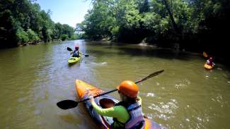
The Neuse River Blueway is a paddling trail that connects over 2,000 acres of parks, greenways, and open space along 25 miles of the Neuse River that flows through the City of Raleigh and Wake County.
Raleigh Parks currently provides six launches for non-motorized watercraft (canoes and kayaks) along 17 miles of the Neuse River, starting at the Falls Lake Dam. The access points are designed specifically for paddlecraft and are open from sunrise to sunset.
Note: Overnight use is not permitted at the parking lots of river access points. Cars may not be left overnight.
Safety
- Fast moving currents can make it hard to reach shore, push you into obstructions, or even capsize your boat. Avoid entering the river during periods of high flow
- Stay clear of obstructions like downed trees, boulders, log jams, or bridge footings which can trap boats and people underwater.
- The bottom of the river is uneven – never stand in water deep enough to float you. If you end up in the water unexpectedly, float on your back with your feet facing downstream.
- Exit the water at the first sign of thunder and lightning.
- Never get in the water while intoxicated or impaired.
- Always wear a life jacket when on the river.
Locations
Below are the river access locations, including directions and river miles from Falls Dam, and their distances apart.
Distance Between River Access Points
| Site Name | Distance to Next Location |
|---|---|
| Falls Dam | 4.7 miles |
| Thornton Road | 5.6 miles |
| River Bend Park | 1 mile |
| Buffaloe Road | 6 miles |
| Anderson Point | 1.5 miles |
| Poole Road | N/A |
Falls Dam
- Address: 12098 Old Falls of the Neuse Road
- Mile: .25
- Directions: From the I 540 take Falls of the Neuse Road exit 14. Travel three miles and just before crossing over the Neuse River turn right on a gravel road which ends at the access point. Turning left before the bridge will end in the Army Corps of Engineers parking lot which has access to the base of the dam.
- Amenities:
- Parking area that includes double parking for trailers
- ADA parking
Thornton Road
- Address: 6100 Thornton Road
- Mile: 4.5
- Directions: From the I 540 take Capital Blvd/US 1 North. Turn right on Thornton Road. Stay on Thornton Road at the stop sign. Take a right into a gravel parking lot. The river access point is a half-mile down the paved greenway trail. Walk and carry your boat to the “T” intersection on the greenway. Turn right on the greenway and walk a short distance to the access points. Signs mark the location.
Buffaloe Road
- Address: 4901 Elizabeth Drive
- Mile: 10.7
- Directions: From the I-440 beltline take Route 64 East exit 11B. Travel two miles and turn right on Buffaloe Road. Travel 3.6 miles and just before crossing over the river turn right on Elizabeth Drive which will end at the access point.
Anderson Point
- Address: 20 Anderson Point Drive
- Mile: 16.2
- Directions: From the I-440 beltline take Route 64 East exit 13B. Travel 2.1 miles on New Bern Ave. Turn right on N. Rogers Lane. Follow until you reach a stop sign. Take a right to stay on N. Rogers Lane. Turn Left on Robbins Drive. Take the first right onto Anderson Point Drive. Turn left into a small parking lot before crossing the bridge over Highway 64 into Anderson Point Park. At the end of the parking lot is a gravel road that leads to the river access.
- Amenities:
- Restrooms (3/4 to 1 mile walk from river access point into Anderson Point Park)
Poole Road
- Address: 6501 Poole Road
- Mile: 17.7
- Directions: From the I-440 beltline take the Poole Road East exit 15. Travel 2.4 miles and turn left on the gravel road best before crossing over the river.
- Amenities:
- Parking area that includes double parking for trailers